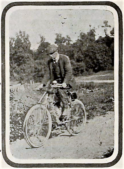
Saturday, June 6, 2026

June 8 - Across America on a Motor Bicycle

(Ogallala to Maxwell, NE)

c.1900
"It is now the time of the heavy rains, cloudbursts and freshets that devastated so much of the Western country during the month of June. It is my luck to be right in the particular great basin where the waters flow most copiously. At Ogallala, Nebraska, I was told that there had been nothing but rain there for the last two weeks. The roads were in terrible condition, I know, when I left there at 6:45 o'clock, on the morning of June 8. After 10 miles of heavy going through the mud, I struck sand, and then took to the railroad track once more. After going six miles over the ties it began to rain so hard that I had to get off and walk three miles to the station at Paxton. There I waited for three hours until it stopped raining, and set out again at 12:30 o'clock. From there it is just 31 miles to North Platte, and as the sun had come out, I returned to the road. I found it good in places and sandy in spots. There was one stretch, two miles long, so sandy that I had to walk it. It was like being back again in the deserts. I got gasoline at North Platte and pushed on 16 miles to Maxwell, which made 70 miles for the day's travel.

Maxwell is a little bit of a place, and I had to take accommodation in a room that had three beds in it. A couple of surveyors were in one of the other beds, and at midnight, a commercial traveler was ushered in and given the third bed. I was fortunate in having a bed to myself at all the small places, for "doubling up" is quite the common thing where accommodations are limited. One more cyclometer was sacrificed on the ride from Ogallala to Maxwell, snapped off when I had a fall on the road. I do not mention falls, as a rule, as it would make the story one long monotony of falling off and getting on again. Ruts, sand, sticks, stones and mud, all threw me dozens of times. Somewhere in Emerson I remember a passage about the strenuous soul who is indomitable and "the more falls he gets moves faster on." I would like to see me try that across the Rockies. I didn't move faster after my falls. The stones out that way are hard."

Community Memorials
608.1 Paxton  - Waypoint Sign and Memorial Plaque 
608.3 Maxwell RON - Waypoint Sign

Across America on a Motor Bicycle - "Over the Rockies and the Great Divide to the Prairies" by George A. Wyman, The Motorcycle Magazine, August 1903, Vol 1 No 3
Ogden, UT to Omaha, NE
May 28 to June 11, 1903

June 7 - Across America on a Motor Bicycle

(Kimball to Ogallala, NE)

"On Sunday morning, June 7, I left Kimball, Nebraska, and made the biggest
G.Wyman
day's run that I scored west of the Mississippi. It is a fine, grain-growing country that I rode through from Kimball, which is a prosperous town. For the first 12 miles the country was rolling and the roads sandy. After that I found good hard roads all the way to Sidney, 35 miles from Kimball, and I made it in just three hours, reaching Sidney at 10:15. When I rode into the place, which is a division town, I passed as tough a bunch of citizens as I met all through 
the West. They were young fellows loafing on a corner, and they tossed all manner of taunting comment at me, as if inviting trouble. I kept on my way without replying, which was wise, but not easy to do. After getting some gasolene(sic), I left at 10:30, and had no trouble making Chappell at 12:15, where I had dinner. 


G.Wyman
I started again at 1:07 p.m., and quickly found that the good road was at an end. It became so bad, in fact, that I took to the railroad and rode the ties most of the way into Ogallala, 114 miles from Kimball. Of this distance I made the first 65 miles in five hours, and had I had as good going in the afternoon as I had in the morning, I would have made 140 miles. It began to rain shortly before I got to Ogallala, and I had to pedal over the last 15 miles. Of the 114 miles I made this day, 46 were ridden in the State of Colorado, for the railroad and road both put in a bend from Chappell southward to get to the South Platte River at Julesburg, Colorado and then the road follows the river valley back again into Nebraska; so that 46 miles was all of Colorado I saw. I found one good stretch of road five miles long in the 46 and this was a relief from the railroad ties so I blessed it and took a snapshot of it for a Colorado souvenir. Ogallala is only a "little jerkwater station," as they say in this country, but it was nightfall when I reached there, and it was raining hard, so I put up there for the night."

Community Memorials
607.1 Sidney Gas - Waypoint Sign & Memorial Plaque
607.2 Chappell -  Waypoint Sign & Memorial Plaque
607.3 Julesburg - Waypoint Sign & Memorial Plaque
607.4 Ogallala RON - Waypoint Sign & Memorial Plaque

Across America on a Motor Bicycle - "Over the Rockies and the Great Divide to the Prairies" by George A. Wyman, The Motorcycle Magazine, August 1903, Vol 1 No 3
Ogden, UT to Omaha, NE
May 28 to June 11, 1903

Friday, June 5, 2026

June 5 - Across America on a Motor Bicycle


(Layover in Cheyenne, WY)


"The next morning I washed and pinned up my rags as best I could and went out to replenish my wardrobe. I must indeed have been a tough-looking specimen the night before, because the first place I went into in the morning, a furnishing store, the dog growled at me savagely and disputed my entrance until called off by his owner. It rained hard all day, and I remained in Cheyenne. while there I weighed myself and found that I was 12 pounds under my normal weight, the scales tipping at 141 pounds. I spent most of the day cleaning and fixing my wheel. Again, I aimed a hose on it, and after that I had to use a scraper and brushes before I could get down to work with a rag. I worked in the bicycle shop of G.D Pratt while there, and he extended me every courtesy."


Community Memorials

Across America on a Motor Bicycle - "Over the Rockies and the Great Divide to the Prairies" by George A. Wyman, The Motorcycle Magazine, August 1903, Vol 1 No 3
Ogden, UT to Omaha, NE
May 28 to June 11, 1903

June 6 - Across America on a Motor Bicycle

(Cheyenne, WY to Kimbell, NE)

"It was raining a little when I left Cheyenne, and the roads were too heavy to ride. I took to the railroad again, and the railroad ties were not much better than the road. For 43 miles I had to pedal. If you ever went for a ride on a tandem and took your best girl, or some other fellow's best girl, and she was a heavyweight, and about 30 miles from home she gave out and you had to do all the pushing to get home, you have a slight idea how I felt pushing the motor over the railroad ties. I got to Egbert at 12:45 and had dinner at the section house there. It is downhill all the way now. I have turned my back upon the Rockies and their grandeur and am nearing the great prairie lands. I can see Elk Mountain, which, with its snow-capped peak is a landmark for hundreds of miles around and in spite of the troubles I have had in the rocky country, I feel somewhat regretful at leaving it. I do not know what troubles the prairies hold for me, and I shall miss the inspiration of the mountain air, the gorgeous view, and the coyotes and the glimpses of antelope that I caught a couple of times back near Laramie. One new sight I do have is that of prairie dogs, and as they sit beside their holes and yelp at me I take several pot shots at them. They dodge into their burrows so quickly that you cannot tell whether you hit them or not: even when shot through the head or heart these creatures dodge into their holes to die. It began to rain when I had gone a mile and a half from the station house, and, remembering my last experience with the rain and the gumbo mud, I turned back and waited at the telegraph operating room until the middle of the afternoon, when the rain slackened. I got to Pine Bluffs on the state line between Wyoming and Nebraska, at 4:40 p.m. To furnish an idea of how rapidly I have come down it may be mentioned that at Pine Bluffs the elevation is 5,038 feet, and this is only 90 miles from the summit, where the elevation is 8,590 feet, a drop of 3,500 feet in less than 100 miles.

During my first few miles of travel in the state of Nebraska I was nearly killed by a freight train. l was riding alongside the track, close to the outer rail, where the dirt over the ties is level, and a strong wind was blowing in my face, so that I did not hear the rumble of the train. Suddenly I heard the loud shriek of the whistle right in my ears. I looked back and the train was not more than 10 yards away. I just had time to shoot down the embankment, which, luckily, was only about four feet high at that place when the train ran past me. As it was, the engineer had whistled "down brakes" and was scared himself. It is fortunate that I was not riding between the tracks at the time, or I would have surely had to sacrifice my bicycle to escape with my life. If it had been a fast passenger train and got that close to me, it would have hit me before I got out of the way. This was worse than the mountains, for nothing that happened there came so near to causing heart failure. I got to Kimball, 65 miles from Cheyenne at 6:50 p.m. They told me there that the roads are good when it is not raining. I had to take their word for it, and conclude that I still carry some sort of a hoodoo with me, in spite of having shed my fancy waistcoat, for when I get into a region of good roads it rains and spoils them, and when it doesn't rain I am in a district where the roads are never good."

Community Memorials

Wednesday, June 3, 2026

June 4 - Across America on a Motor Cycle

(Laramie to Cheyenne, WY)

G.Wyman
"Up in the air was the program from Laramie - almost straight up it seemed to me at times, so steep was the road. They told me in the town that by leaving the railroad and taking the road over the ridge I would save 20 miles. Maybe I did. I went over the "ridge" anyway. I climbed steadily for 8 miles, and when I reached the summit I was at the highest point I touched in my entire trip, and higher up than I ever was in my life before. The altitude at the top is 8,590 feet. Going up I followed a narrow trail full of stones and sharp twists around boulders and the best guide I had to keep from going wrong was the hoof-prints of the presidential party that had gone over the summit the day before. It would have been easy to have lost the trail had it not been for the hoof-prints, but I followed them and knew that I was right, for the President's party had a guide. At the summit is a flagstaff, put there by a survey party I believe, and someone in the Presidential party had hoisted a handkerchief on it the day before, so I took a snapshot of it. Then, before I left I rested myself by putting this inscription on the pole: "G.A. Wyman, June 4, 1903, 11:30a.m. - First motorcyclist to cross the Rockies, going from San Francisco to New York."

While I was on this summit, it clouded up and began to thunder ominously. I had no more than started on the descent than it began to rain in torrents. The water just dropped from the clouds as if they were great lakes with the bottoms dropping out. In one minute I looked as if I had been fished out of a river. There was no place to seek shelter. either(sic), not even a small tree, for the mountaintop is "bald," so I had to keep going. After running down about three miles my belt would not take hold and I had to get off and walk. So long as I was on the ridge where the ground was all rocks it was not so bad, but when I began to get down to the lower-lying land my trouble settled upon me in earnest. Down at the bottom I struck gumbo mud, and it stuck me. Gumbo is the mud they use in plastering the crevices of log louses. It has the consistency of stale mucilage and when dry is as hard as flint. It sticks better than most friends and puts mucilage to shame. When you step in it on a grassy spot and lift your foot the grass comes up by the roots. My wheel stood alone in the gumbo whenever I wanted to rest, and that was pretty often. Every time I shoved the bicycle ahead a length I had to clean the mud off the wheels before they would turn over again. I kept this up until finally I reached a place where I could not move the bicycle another foot. It sunk into the gluey muck so that I could not shove it either forward or backward. I found that it had taken me two hours to travel half a mile, and I could not see New York looming in front of me with any particular prominence. In fact, I could not see a sign of any settlement or human habitation anywhere, and I was in a quandary what to do. I had set out to travel to the Atlantic coast with my motor bicycle, and thus far I had done so, though I had done some walking, I did not like to part with the machine right there, for in the long run, the walking would be worse than the riding. I finally left the bicycle sticking bolt upright in its bed of gumbo mud and set out to find a place where someone lived. This move led me to a pleasant experience, the hospitality of the Wyoming ranchers.

After walking two miles I came to a ranch house, and I was lucky to find it for there is not another house within seven miles. The young man I met there immediately hooked up a team of horses and went back with me and pulled the wheel out of the mudhole. When I got to the house my rescuer, who was R.C. Schrader, of Islaly(sic) Station, Wyoming lent me a hose, and with the aid of a stream of water and a stick, I got the machine fairly clean after an hour of hard work. Mr. Schrader was a hearty host. I had eaten nothing since an early breakfast, and it was then 5 p.m. He made me stop and eat, and then, as I insisted on pushing along, he showed me the way to the railroad track. I was glad to see the ties again. It was about 20 miles to Cheyenne, and I walked most of the way, arriving there at 10:30 p.m. About an hour after I left the Schrader farm it began to rain and kept it up till I was within two miles of Cheyenne. When I reached there I was a sight for men and dogs. I was mud and tatter from head to feet. A colony of tramps would have been justified in repudiating me, for my face had been washed in streaks and the mud remaining on it was arranged as fantastically as the war paint of an Indian buck. My shirt is splashed with mud, too, and I miss my vest because I could remove it and make a better front in the town, I have missed that waistcoat all the afternoon, for there was snow mingled with the rain and I was cold: but I took off he vest, a light, fancy affair, some time before reaching Laramie and threw it away because I took a notion it was a hoodoo.

With my coat torn in several places and one sleeve of it hanging by a thread, my leggings hanging in shreds, no waistcoat on, dripping wet and splashed with mud all over, I checked my bicycle at the baggage room of the railroad station and set out to find a room in Cheyenne. "All full" was the word I got at the first hotel, and at the next it was the same. After I had tried three and been refused, I was satisfied that it was my appearance that was the reason. To make the matter worse, I discovered that my big ".38" revolver had worn a hole in my pocket and was sticking through so that it showed plainly between the torn part of my coat. I must have looked like a "bad man" from the wilds that night, and, realizing this, I made it a point to tell my story In explanation, after I had been refused accommodations at the hotels. After visiting a couple of boarding houses and being turned away I finally found a woman who kept furnished rooms, who eyed me suspiciously and said she had no room, but would fix me up a cot. She listened to my story and finally fixed me up a nice room, and I stayed there two nights. "

Research Note:  Wyman noted in his diary the rancher who assisted as "R.C. Schrader of Islaly(sic) Station."  The Wyman Project research discovered the likely identity as R.C. Shaver. In 1903, R.C. Shaver served as station agent of Islay Station. He was often listed as the postmaster for the Islay post office. The Shaver ranch is 8 miles south of the circa 1903 Islay Station. It is at the approximate location of Wyman's decent from the Sherman mountains along Happy Jack Road.

1905 Sherman, USGS Historic Topographical Maps


Community Memorials
604.1 Sherman Summit  - Waypoint Sign, Memorial Plaque, Journey & Waypoint Posters
604.5 Cheyenne Depot - Memorial Plaque, Journey & Waypoint Posters

Across America on a Motor Bicycle - "Over the Rockies and the Great Divide to the Prairies" by George A. Wyman, The Motorcycle Magazine, August 1903, Vol 1 No 3

Ogden, UT to Omaha, NE
May 28 to June 11, 1903

Monday, June 1, 2026

June 2 - Across America on a Motor Bicycle

(Walcott to Laramie, WY)

"From Walcott, which I left at 6:30 a.m., it is uphill traveling eastward all the way to Laramie. I passed through the mining town of Hanna, peopled mostly by Finns and Negroes, and past the railroad stations of Edson, Dana, Allen and Medicine Bow. At the place last named I ripped out some more spokes, and after fixing up the damage temporarily, I took to the railroad and followed it, in preference to the road, into Laramie. This was the first place that I really felt enthusiastic from the time I left the coast. Laramie is a big, fine place of nearly 10,000 and is in the greenest country I had seen since I left Sacramento. That is how it struck me, and I felt glad to be there. It seemed as if it was a place where someone lived and where folks could live. It is a fertile country all around there, given over largely to sheep and cattle ranching, and has a natural, civilized look that I did not find anywhere in Nevada, and only in little touches in Utah between big stretches of wilderness. I saw some of the finest baldface, big-horn cattle there that the country produces. This is where Bill
Lovejoy Motorcycle Garage, c.1905
Nye appeared on the horizon of humor, I believe, when he was "sticking" tape for the Laramie Boomerang. I recalled this and could understand that a man might be a humorist living in such a place. I could not revel in the delights of Laramie as I would have liked, for I had troubles of my own to attend to. It was 7:05 p.m. when I got there, and I hunted up the bicycle shop of Elmer Lovejoy. He furnished me with five new spokes and placed his shop at my disposal, for I preferred from the first to do all the repairing to the motorcycle myself."


Community Memorials
602.4 Medicine Bow - Waypoint Sign and Memorial Plaque
602.4i Bosler Depot
602.4i Rock River Depot
602.5  Lovejoy Garage - Waypoint Sign & Memorial Plaque

Across America on a Motor Bicycle - "Over the Rockies and the Great Divide to the Prairies" by George A. Wyman, The Motorcycle Magazine, August 1903, Vol 1 No 3
Ogden, UT to Omaha, NE
May 28 to June 11, 1903


Sunday, May 31, 2026

June 1 - Across America on a Motor Bicycle

(Bitter Creek to Walcott, WY)

"After having breakfast in the boxcar restaurant, I left Bitter Creek for Rawlins. In this stretch, about 20 miles from Bitter Creek, I crossed my third desert, the Red Desert of Wyoming. It takes its name from the soil of calcareous clay that is fiery red, and the only products of which are rocks and
G.Wyman
sagebrush, and they will grow anywhere. There is a Red Desert Station on the map, but there is nothing there but a telegraph office, and the same is true of Wamsutter and Creston, the succeeding names on the map. I took a snapshot of the road in the desert near Bitter Creek and wrote on the film: "Who wouldn't leave home for this?" East of Red Desert the road improved considerably, and from Wamsutter to Creston it was really fine.


It was along this fine stretch, just before reaching Creston, that I came to the
G.Wyman
Great Divide and took a picture of the signpost, which marks the ridgeline of the great American watershed. Standing there and facing the north, all the streams on your left flow to the west and all those on the right side flow toward the east, the waters of the former eventually finding their way to the Pacific, and the latter to the Mississippi River. This is the backbone of the continent and it is duly impressive to stand there and gaze at the official sign. It does not mark the exact middle of the continent though, as some have mistakenly thought. It is about 1,100 miles east of San Francisco. I had rather expected to find the continental divide, if I did come across it, on the summit of a mountain, in a very rough piece of country, but it is in a broad pass of the Rockies, that seems more like a plain than a mountain, although a commanding view is obtainable from there. To the north are the Green, Febris and Seminole chains of mountains, and further, in the northwest is the Wind River range, and beyond that again the Shoshone range, while to the south are the Sierra Madres, all escalloping the horizon with their rugged peaks, here green, there shrouded in a purplish veil, and far away showing only a hazy gray of outline. One realizes that he is in the Rockies positively enough.


G.Wyman

From Creston to Rawlins there is nearly 30 miles of downgrade, and, as it is a fairly good highway of gravel, I made lively time over it. After leaving Creston there come Cherokee and Daly's ranch before you get to Rawlins, and it was between these places, both mere railroad points, that I got the picture of the abandoned prairie schooner that was printed in Motorcycle Magazine. Rawlins, where I stopped only for gasoline, is a town of some size, having more than 2,000 population. From there the country becomes rolling again, and after passing Fort Fred Steele, I began to ascend once more. It is a great sheep ranch country all through here now from Rawlins. At Fort Steele there is nothing left but the ruins of abandoned houses. I now follow the old immigrant trail that winds across the River Platte, and am fast approaching the Laramie Plains, over which my route lies to the Laramie Mountains. Beyond Fort Steele I enter White Horse Canyon, which got its name, so the story goes, from an Englishman, one of the sort known in the West as "remittance men," who drank too much "Old Scratch," and, mounted on a white horse, rode over the precipice and landed on the rocks 200 feet below.

At 6:10 p.m. I reached Walcott, a "jerkwater" settlement, composed of two saloons, a store and a railroad station. It is made important, though, by the fact that two stage lines come in there. The hotels at places of the sort are generally clean, and they are kept more-or-less peaceable by the policy of reserving an out-building for the slumbers of the "drunks," so I concluded to tarry. I found some interest in automobiles here, and, after inspecting my machine, the natives fell to discussing the feasibility of running automobiles on the stage lines, instead of the old Concord coaches, drawn by six horses, that are now used. One of the stage drivers said that if anyone would build an automobile that would carry 12 or 14 persons and run through sand six inches deep. He would pay from $3,000 to $5,000 for it. I told him to wait awhile. After supper I mended my broken spokes with telegraph wire, and entertained quite a group of spectators, who watched the job with open curiosity. I find a variable reception in this country to my statement that I have journeyed from San Francisco, and am bound for New York. A great many do not believe me, and smile as if amused by an impromptu yarn. There is another class, though, that of the old settlers, the real mountaineers who have had adventures of all sorts in the mountains and the wilderness. These men are surprised at nothing, and they rather nettle me by accepting me and my motor bicycle and my statement with utmost stolidity as if the feat was commonplace. For awhile I thought that this class, too, were unbelievers, but later I learned that as a rule they are the only ones who do believe me, because they are men who believe anything possible in the way of overland journeying."

Community Memorials
601.8 Fort Steele - Memorial Plaque & Waypoint Sign
601.9 Walcott RON - Journey & Waypoint Posters

Across America on a Motor Bicycle - "Over the Rockies and the Great Divide to the Prairies" by George A. Wyman, The Motorcycle Magazine, August 1903, Vol 1 No 3
Ogden, UT to Omaha, NE
May 28 to June 11, 1903


Subscribe to get email updates of our...  
'What's New' to You!"

Saturday, May 30, 2026

May 31 - Across America on a Motor Bicycle

(Granger to Bitter Creek, WY)

"Leaving Granger, which is a division town of about 200 people and has one hotel, at 6:30 o'clock in the morning, I found the road to Marston terribly rocky, and I returned to my old love, the crossties, after going half the distance, or about six miles. At Marston I found the old stage road to Green River, and many portions of this are gravelly and fine. Green River is quite a place with a population of about 1,500, but I did not stop there. I pushed on past the famous castellated rocks to Rock Springs, 45 miles from Granger, and, arriving there at 11:45, I stopped for dinner. You always eat dinner in the middle of the day in this part of our glorious country, and if you get up with the sun and bump on a motorcycle over the hallways of the Rocky Mountains, you are ready for dinner at 12 o'clock sharp, and before. At Rock Springs the country begins to look upward again, the elevation there being 6,260 feet, 200 feet more than at Green River. From Rock Springs on, except for one drop of 500 feet from Creston to Rawlins and Fort Steele, there is a steady rise to the summit, about half way between Laramie and Cheyenne. There the elevation is a cool 8,590 feet.

Rock Springs, where I had dinner, is in the district of the Union Pacific Company's coal mines. It is memorable for labor troubles and murders of Chinamen. I had the ends of my driving belt sewed at Rock Springs, and set out again past Point of Rocks, 25 miles east to Bitter Creek. East of Point of Rocks the road Is fairly level, but it is of alkali sand, and when I went over it, it was so badly cut up that in some places I had to walk.

Bitter Creek might well be called Bitter Disappointment. I do not mean the stream of water that the road follows, but the station of the same name. It is one of those places which well-illustrates what I have said about the folly of taking the map as a guide in this country. About one-third of the "places" on the map are mere groups of section houses, while a third of the remainder are just sidetracking places, with the switch that the train hands shift themselves, and a signboard. Bitter Creek belongs to the former class. The "hotel" there is an old boxcar. Yet, if you take a standard atlas you will find the name of Bitter Creek printed in big letters among a lot of other "places" in smaller type. The big type, which leads you to think it must be quite a place, means only that the railroad stops there. The "places" in smaller type are mere sidetracking points. The boxcar is fitted-up as a restaurant and reminds one faintly of the all-night hasheries on wheels that are found in the streets of big cities. The boxcar restaurant at Bitter Creek, however, has none of the gaudiness of the coffee wagons. Still, I got a very good meal there. When I cast about for a place to sleep it was different, but I finally found a bed in a section house. This experience was one of the inevitable ones of transcontinental touring. It was 7:15 o'clock when I reached Bitter Creek Station and it is 69 miles from there to Rawlins, the first place where I could have obtained good accommodations."

Community Memorials
531.3 Point of Rocks - Waypoint Sign & Posters
531.4 Bitter Creek RON - Waypoint Sign

Across America on a Motor Bicycle - "Over the Rockies and the Great Divide to the Prairies" by George A. Wyman, The Motorcycle Magazine, August 1903, Vol 1 No 3
Ogden, UT to Omaha, NE
May 28 to June 11, 1903


Friday, May 29, 2026

2026 Wyman Trail Survey - West

The Wyman Trail Survey is conducted each year to review existing Wyman Community Memorial displays and establish new ones. This year's survey is jammed pack with new additions to the growing number of Wyman Community Memorial displays. 

Follow along as we travel the Wyman Trail from San Francisco to Council Bluffs.  SpotWalla Tracking Map 

Wyman Waypoint Coordinators David & Tracy Hoover have worked tirelessly setting up the significant additions to the Community Memorials listed below.

Happenings between San Francisco CA and Council Bluffs IA include:

516.1 Lotta's FountainPresentation to the San Francisco Motorcycle Club to secure mounting of the large Wyman Memorial Plaque at Lotta's Fountain or at the north pier of the Embarcadero. 8pm June 4, 2194 Folsom Street, San Francisco CA

520.5 Reno RONWyman Memorial Plaque & Waypoint sign placement meeting with Comstock Chapter of Antique Motorcycle Club at the National Automobile Museum, afternoon of Friday, June 5, 1 Museum Drive, Reno NV

606.3 KimballWyman Memorial Plaque dedication ceremony. 1pm Saturday, June 6. Kimball Plains Historical Society Museum, 2nd & Chestnut Street, Kimball NE

607.1 SidneyWyman Memorial Plaque dedication ceremony. 2pm  Sunday June 7. Pedaler's Corner, 840 9th Ave, Sidney NE

607.2 ChappellWyman Memorial Plaque dedication ceremony. 10am Sunday June 7. 641 Gold Rush Byway, Chappell NE

610.1 Grand Island:  Wyman Memorial Plaque dedication ceremony. 10am Wednesday June 10. Hall County Historic Society at Burlington Station, 603 N Plum Street, Grand Island NE

610.4 Columbus:  Wyman Memorial Plaque dedication ceremony. Afternoon, Wednesday June 10. The Columbus Area Antique Fire Apparatus Museum, 2302 13th Street, Columbus NE

612.3 Council Bluffs:  Wyman Memorial Plaque dedication ceremony. 6pm Friday June 12. Union Pacific Museum, 200 Pearl St, Council Bluffs IA 

In 2025 David & Tracy Hoover volunteered as Wyman Waypoint Coordinators.  Their first success was 609.3 Kearney NE.  Working with the Great Platte River Road Archway monument & museum, David & Tracy secured hosting of the Wyman Memorial Plaque with Waypoint Sign mounted outside the Archway Museum and a fabulous display of  Wyman journey integrated with the Archway guided tour. 

David Hoover is a member of the Antique Motorcycle Club of America.  His passion for motorcycles of the 1900s naturally extends to his desire to bring the Wyman story to the communities along the Wyman Trail.  David & Tracy have worked the Wyman Trail to significantly increase the number of Community Memorials along Nebraska and Iowa.  He wrote an article for the AMCA publication that has sparked interest in the Wyman story. The Comstock Chapter of the AMCA has reached out to David to coordinate Community Memorial displays in Nevada. 

May 30 - Across America on a Motor Bicycle

(Evanston to Granger, WY)

"After riding about six miles that day I bumped into a rut and the stem of my handlebars snapped, but there was about an inch of the stem left, and I hammered it down with my wrench into the head tube and managed to make it do. This repair lasted to Chicago. I took to the railroad leaving Evanston, as there has been a new section built there, cutting off some distance and leading through a newly completed tunnel at Altamont, 13 miles from Evanston. 

It was early morning when I reached the tunnel. It is a mile and a half long. A train passed me and through the tunnel just before I got to it. It takes half an hour for the smoke to get out of the tunnel after a train passes through. I sat down to wait at the station and got to talking to an operator. He calmly informed me that several other trains would be along before long, and that it would not be safe for me to go through the tunnel for hours. Such luck! The only thing for me to do was to follow the trail over the summit through which the tunnel runs. This I did, walking and pushing my bicycle and stopping every few minutes to "breathe" myself. I ascended 300 feet in less than half a mile. I rode down on the other side using both hand brake and the coaster brake. I forsook the railroad after this and followed the road through Spring Valley and Carter to Granger, riding past the famed buttes, or table mountains of the Bad Lands. Bad they are, too. Even the road was marshy and muddy with clayey, sticky mud that just hugged my tires and coaxed them to stay with it. I was going down-grade now from Altamont to Granger. 

It is a great country at
Carter, WY c.1900
Carter, where altitude is 6,507 feet, it is a wonderful sight to see the buttes with seashells on their sides marking the high water mark of a prehistoric flood. Only it is a pity the water would not dry up entirely and give a bicycle a chance. I covered 85 miles on this day and it was one more like the three preceding days. An idea of climbing can be gained by stating that at Evanston the elevation is 6,759 feet, at Altamont 7,395 feet, and at Granger 6,279 feet. There were more round stones the size of baseballs on that piece of trail over the Altamont summit than ever I saw before in my life. At times they all seemed to be rolling around in an effort to get under my tires. If ever I travel through Nevada. Utah and Wyoming again on a bicycle it will be with a railroad track attachment. The telegraph operators at the lonely stations in the deserts have them to travel on back and forth from their homes to their offices. Putting the flanged guide wheels of the attachment on one rail the wheels of the bicycle are kept strictly in place on the opposite rail, and splendid time can be made. With such an attachment and a motor bicycle one could follow the railroad and make 150 miles a day, rain, snow or sunshine."


Community Memorials

Across America on a Motor Bicycle - "Over the Rockies and the Great Divide to the Prairies" by George A. Wyman, The Motorcycle Magazine, August 1903, Vol 1 No 3
Ogden, UT to Omaha, NE
May 28 to June 11, 1903


Subscribe to get email updates of our...  
'What's New' to You!"